REVIEW · PORTLAND
Mt. Hood & Multnomah Falls Air Tour by Envi Adventures
Book on Viator →Operated by Envi Adventures, LLC · Bookable on Viator
Mt. Hood from the sky hits different. This air tour flies you from the Portland area out over the Willamette Valley and up toward Oregon’s highest peak, then returns through the Columbia River Gorge with waterfall and landmark views only birds usually get. I like the private-feeling small group setup (max 5 travelers), and I also love how the flight is built for photos: you’re looking straight out the windows instead of sitting in traffic.
There’s one big thing to plan around: this experience is very weather dependent, and the route can change at the pilot’s discretion.
In This Review
- Key highlights at a glance
- A private-jet style loop over Mt. Hood and the Columbia Gorge
- Price and value: what $279 per person really buys
- Meeting in Troutdale and what to expect before you fly
- Weather is the boss: routing changes and Mt. Hood expectations
- First stop: Willamette Valley views that set the tone
- Mt. Hood: Wy’east, the stratovolcano, and the Oregon high point
- Mount Hood National Forest: where the ground texture changes
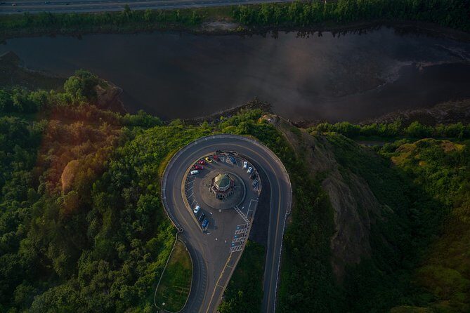
- Beacon Rock: a monolith with flood-sculpted edges
- Multnomah Falls from above: waterfall speed and seasonal flow
- Sandy River and Latourell Falls: less famous, still scenic
- Vista House and Crown Point: cliffs and viewpoints in one pass
- Bridge of the Gods: a man-made landmark with river scale
- Small-plane reality: who will love it and who might not
- Should you book this Mt. Hood and Multnomah Falls air tour?
- FAQ
- How long is the Mt. Hood and Multnomah Falls air tour?
- Where do I meet the tour?
- Is bottled water included?
- What aircraft do they use?
- What is the maximum group size?
- Is the route guaranteed, including how close you fly to Mt. Hood?
- What happens if the weather is poor?
- Are there weight limits?
- Can kids participate?
- Is there free cancellation?
Key highlights at a glance
- Private group size (max 5): more elbow room and less crowd noise than big sightseeing buses.
- Photo-forward flight path: you get sky views of waterfalls, bridges, and cliffs that are hard to appreciate from the road.
- Bottled water included: a small comfort that matters on any trip that spends most of its time in the air.
- Mt. Hood in one flight: the highest point in Oregon, plus the surrounding forest and volcanic terrain.
- Gorge geology from above: Beacon Rock, Multnomah Falls, and other features made by ice-age flooding and the river system.
A private-jet style loop over Mt. Hood and the Columbia Gorge
This is the kind of outing that makes you rethink distance. From Troutdale, you hop into an airplane and within about an hour you can see a whole “greatest hits” mix of Oregon: volcanic peaks, gorge walls, waterfalls, and even major river crossings. No long drive. No parking battles. Just window time.
The real win is how the flight stitches together places that are spread out on the ground. From the air, Mount Hood doesn’t just look tall, it looks layered. The Columbia River Gorge doesn’t just look scenic, it looks carved—by time, water, and floods on a scale you can actually picture.
And because it’s set up as a small group experience, you’re not fighting for a view. If you’re going with family, friends, or a couple, you tend to get a calmer vibe. In past flights, pilots like Carrie, JP, John, Davis, Dave, Clay, and Spencer have been praised for being friendly and informative. (That kind of pilot matters a lot in the air, when you want clear explanations and smooth handling.)
More Multnomah Falls & Columbia River Gorge Tours in Portland


Price and value: what $279 per person really buys
At $279 per person for about an hour, this isn’t the cheapest way to see the gorge. But for what you get, it can be a smart value—especially if you’d otherwise spend time and money on multiple stops.
Here’s why the price can make sense:
- You’re paying for air time over the most dramatic portions of the route. From ground level, you often need separate drives to see these viewpoints well.
- You’re in a maximum of 5 travelers setup. That keeps the experience feeling less like a mass tour.
- Bottled water is included, and you’ll have a mobile ticket for check-in.
If you’re traveling in a small group, you also get a better deal than solo touring of the same sights. The listing notes group discounts, so it’s worth checking your exact party size when you book.
Meeting in Troutdale and what to expect before you fly

You meet at Envi Adventures at 1350 NW Perimeter Way, Troutdale, OR 97060. The tour ends back at the same spot.
Plan to arrive early. All passengers are required to arrive at least 30 minutes prior to the start time. That’s not just a “nice to have.” In small aircraft experiences, getting everyone settled and accounted for is part of what keeps the flight smooth.
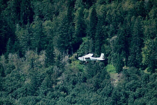
You’ll also be flying as part of a structured, limited-capacity group. This is operated with airplanes, not helicopters, and the max is 5 travelers. That matters because it affects how much total weight is allowed and how quickly the operator can confirm who’s on board.
Two practical notes:
- Bring your mobile ticket details with you.
- Have passenger weights ready when booking. Weight limits are part of the plan for safety and flight operations.
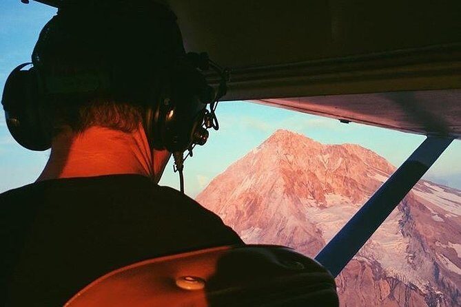
Weather is the boss: routing changes and Mt. Hood expectations
This tour is very weather dependent, and the pilot may use an alternate route. You should treat the exact path as flexible, not fixed.
That matters most with Mount Hood. The provider’s FAA-compliance note (from their response to a disappointed customer) explains an important limitation: routes to Mount Hood can be restricted to within a 25-mile radius from the airport. On top of that, pilots may adjust the route due to weather or conditions, even while staying within that range.
So yes, you can get great views. But if your dream is “show up like the close-up photos online,” manage expectations. The flight is designed to get you into the best view possible for conditions—not to guarantee a specific angle every time.
If you’re traveling during a time of unstable weather, consider booking with some buffer in your schedule. That gives you a better chance of landing the best version of the flight.
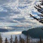
First stop: Willamette Valley views that set the tone
Your flight starts by heading out over the Willamette Valley for about 30 minutes, with an admission ticket noted as included. In plain terms, this first segment is where you settle in and start seeing the region’s shapes from above: river lines, farms and fields, and the broad geometry that makes Oregon’s valleys feel so distinct.
This portion is also useful as a warm-up for your eyes. Once you’ve seen the valley layout, the shift into the gorge and mountain terrain feels more dramatic. You’ll find it easier to spot where rivers cut through, and how the elevation changes before you even get to Mt. Hood.
If you’re the kind of person who likes to “read” a view, this first stretch helps.
More Air Tours & Scenic Flights in Portland


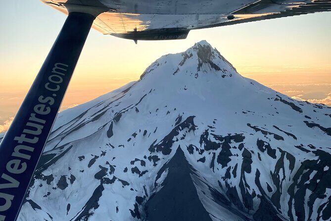
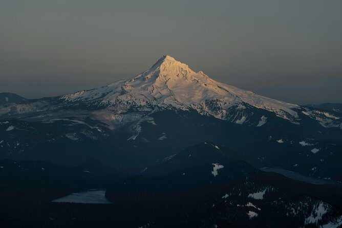
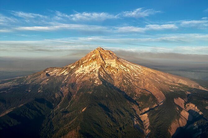
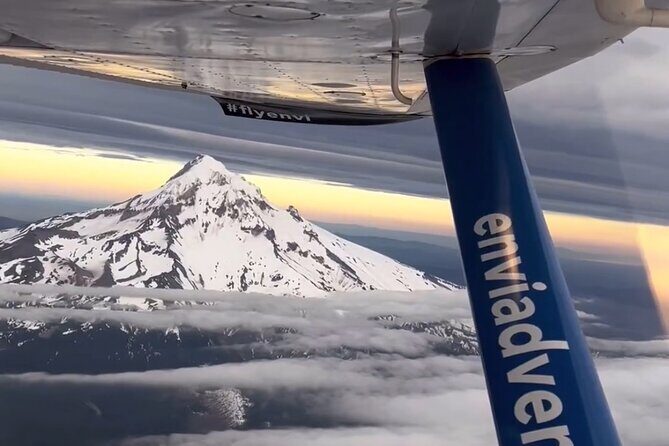
Mt. Hood: Wy’east, the stratovolcano, and the Oregon high point
Next comes Mount Hood, called Wy’east by the Multnomah tribe. Mount Hood is described as a potentially active stratovolcano in the Cascade Volcanic Arc. It formed from the subduction zone on the Pacific coast, and it sits right in the Pacific Northwest context that geologists love to explain—and that you can actually see on a clear day.
You’ll have around 15 minutes for the Mt. Hood portion, and the flight timing is usually about getting you in the right view window rather than rushing you through. Mt. Hood is also the highest point in Oregon, about 50 miles outside of Portland. From the air, “distance” shrinks fast. That 50-mile idea turns into a quick climb in visuals.
What makes this part special:
- You see how the mountain rises above the surrounding forest and valley.
- Even when you don’t get perfect clarity, you still get a strong sense of shape and height.
- It’s the kind of subject that looks different every time you glance at it.
The drawback: clouds and haze can reduce contrast, and because this is weather dependent, visibility is not guaranteed.
Mount Hood National Forest: where the ground texture changes
After the Mt. Hood highlight, you’ll fly near Mount Hood National Forest for about 15 minutes. This is one of those segments that can feel “less dramatic” than the peak itself, but it’s often the part that makes the whole experience feel grounded.
From above, forests don’t look like forests. They look like texture—patterns of tree cover, changes in elevation, and the breaks where rivers and clearings cut across the slope.
For photographers, this segment can be helpful for switching styles:
- If your goal is a crisp mountain shot, you use the peak window.
- If your goal is the “how the land is built” view, you lean into this forest stretch.
Beacon Rock: a monolith with flood-sculpted edges
Then you head toward Beacon Rock, described as a 57,000-year-old plug from a cinder cone. It’s considered part of the Boring Lava Field, and here’s the key detail: the Missoula Floods scored away much of its flanks, leaving a freestanding monolith.
From the air, Beacon Rock becomes more than a roadside stop. You can actually see it as a leftover of a bigger volcanic shape, stranded in a landscape shaped by ice-age water. That’s the kind of “geology lesson with a view” that’s hard to get when you’re only seeing it from one angle at ground level.
This is a quick segment—around 2 minutes—but it’s a fast hit of meaning. If you enjoy places that have a story in the rock itself, this stop is one of the best.
Multnomah Falls from above: waterfall speed and seasonal flow
Next is Multnomah Falls, one of the top natural recreation sites in the Pacific Northwest, with more than 2 million visitors each year. It’s fed by underground springs from Larch Mountain, and the flow varies—often highest in winter and spring.
You’ll get about 2 minutes for the falls, and that’s enough time to catch:
- the falls’ shape,
- the surrounding gorge walls,
- and the way the water threads through the wider drainage system.
If you’re visiting outside peak flow season, don’t assume it will look exactly like the bold postcards you’ve seen. The tour data is clear: the flow changes with the seasons. From the air, you’ll still see the structure and the drop—just with different water volume.
Also, Multnomah Falls is described as a strong place to study geology exposed by floods. From above, those “why it looks like that” clues are easier to notice because you see both the river system and the cliff face together.
Sandy River and Latourell Falls: less famous, still scenic
Between the big icons, you’ll pass Sandy River, described as a 56-mile tributary of the Columbia River. It joins the Columbia about 14 miles upstream of Portland. From the air, a river like this becomes easy to “read” as a line of movement across the land—especially where it meets the bigger system.
Then comes Latourell Falls, located along the Columbia River Gorge in Oregon within Guy W. Talbot State Park. It’s near the Historic Columbia River Highway, and at certain road spots you can see the lower falls. From the air, you don’t have to hunt the view. You can see the waterfall and the surrounding gorge angle in one glance.
Latourell also gets about 2 minutes. For many people, quick bursts are the right format in an airplane tour. You see it, you photograph it, and you keep moving while the sky is clear.
Vista House and Crown Point: cliffs and viewpoints in one pass
As you circle back through the Gorge, you’ll fly past Vista House at Crown Point. This is one of the most popular viewpoint areas in the Gorge, perched on cliffs above the river. From the air, you get a different relationship between the structure and the drop below it.
This part is especially useful if you’ve ever visited Crown Point by car and felt the viewpoint was too “wide” to appreciate in one stop. From above, you understand how the building sits relative to the cliffs, and how the gorge walls frame everything.
You’ll also have quick 2-minute style passes for the Vista House and Crown Point areas. Again, short time, but it’s a high-value moment because it ties the whole route into a recognizable geography.
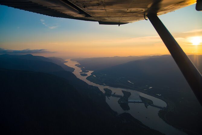
Bridge of the Gods: a man-made landmark with river scale
To finish the loop, the flight passes the Bridge of the Gods. It’s described as a steel truss cantilever bridge that spans the Columbia between Cascade Locks, Oregon and Washington state, near North Bonneville.
Why this matters on an air tour: bridges always look simpler from ground level. From the sky, you can see river width, bends, and how the bridge connects two landscapes that feel far apart by road.
You get about 2 minutes here, and it works like a “frame” for the rest of your memories. It’s the human marker next to the giant natural systems you just saw.
Small-plane reality: who will love it and who might not
This is a short flight with a small group (max 5). That’s exactly why it feels special. It’s also why it’s not for everyone.
You’ll likely love this tour if you:
- want high-impact views in about an hour,
- prefer not to drive between multiple stops,
- care about photos and clear sightlines,
- like the idea of a pilot who shares context on what you’re seeing.
You might want to think twice if:
- you’re expecting a guaranteed, super-close view of Mt. Hood like specific marketing photos,
- you travel with a tight schedule where weather changes would be a problem,
- you don’t like the idea of routing changes at pilot discretion.
And one more practical detail: there are weight limits. Total weight per passenger is 250 lbs, and group weight caps are listed as well. You’ll need to provide weights when booking.
Should you book this Mt. Hood and Multnomah Falls air tour?
If you want one simple plan to see Mt. Hood plus the Columbia Gorge icons with minimal driving, I’d book this—especially if you can be flexible with weather. The combination of small-group setup, bottled water included, and air time over top sights makes it feel like good value for the experience type.
But book with the right mindset. This isn’t a ride that can promise a single exact camera angle every time. It promises a strong shot at unforgettable views—then lets the pilot adjust for real-world conditions.
If you can handle weather uncertainty and you’re excited by aerial views of geology, waterfalls, and river landmarks, this one is a win.
FAQ
How long is the Mt. Hood and Multnomah Falls air tour?
It runs for about 1 hour (approx.), with several short segments over key areas.
Where do I meet the tour?
Meet at Envi Adventures, 1350 NW Perimeter Way, Troutdale, OR 97060, USA. The tour ends back at the same meeting point.
Is bottled water included?
Yes. Bottled water is provided.
What aircraft do they use?
This is operated with airplanes, not helicopters.
What is the maximum group size?
The tour has a maximum of 5 travelers.
Is the route guaranteed, including how close you fly to Mt. Hood?
The tour is very weather dependent and may result in an alternate route at the pilot’s discretion. There can also be FAA-related routing limits (including a 25-mile radius from the airport), so you should expect some variation in angles.
What happens if the weather is poor?
The tour requires good weather. If it’s canceled due to poor weather, you’ll be offered a different date or a full refund.
Are there weight limits?
Yes. Total weight per passenger is limited to 250 lbs, and there are also group weight maximums listed depending on how many people are in the group. You must provide weights when booking.
Can kids participate?
Children must be accompanied by an adult.
Is there free cancellation?
Yes. You can cancel up to 24 hours in advance for a full refund. If you cancel less than 24 hours before the start time, the amount paid is not refunded.
You Might Also Enjoy

More Tour Reviews in Portland
- The Real Portland Tour: City and 3 Lighthouses Historical Tour with a Real Local
★ 5.0 · 1,448 reviews