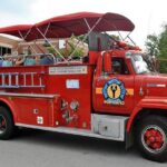
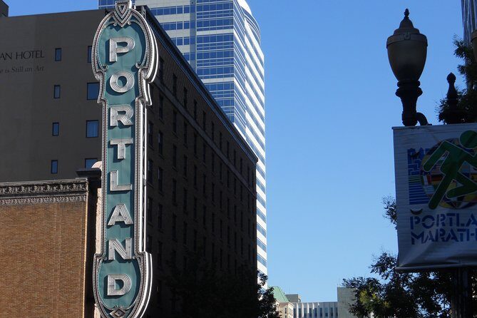
REVIEW · PORTLAND
Mt. St. Helens Air Tour by Envi Adventures
Book on Viator →Operated by Envi Adventures, LLC · Bookable on Viator
Look down at Oregon’s volcano story from the sky. This Mt. St. Helens air tour is interesting because it strings together Portland, the Columbia River Gorge, and the eruption zone into one tight flight plan, with a pilot giving you a running explanation as you go. I especially love the small group feel (maximum of 5) and the way the pilot guides what you’re actually seeing, not just where you’re going. One possible drawback: this tour is very weather dependent, so the exact route can change.
I also like that you get round-trip transportation from Troutdale to the meeting point instead of figuring out everything on your own. It’s run on airplanes, not helicopters, so you may have fewer photo angles than you’d get from a helicopter. Still, at about an hour in the air, it’s a very efficient way to get sky-high perspective on one of the biggest events in U.S. geological history.
In This Review
- Key points to know before you fly
- From Troutdale to the volcano in about an hour
- The flight plan: Portland and the Columbia River Gorge first
- Stop: Columbia River Gorge (the canyon you can actually measure)
- Flying above Portland: rivers, Mt. Hood, and city scale
- Stop: Mt. St. Helens crater views and the May 18, 1980 story
- Stop: Seeing the eruption’s destruction from the air
- Your pilot matters more than you think
- Plane vs helicopter: the photo reality check (with fairness)
- Weather and alternate routing: how to stay flexible
- Timing, group size, and comfort on a small flight
- Who should book this Mt. St. Helens air tour
- Should you book this Mt. St. Helens Air Tour with Envi Adventures?
- FAQ
- How long is the Mt. St. Helens Air Tour?
- What does the tour cost?
- Where does the tour start from?
- Is this tour operated with a helicopter?
- Does weather affect the route?
- What is the maximum group size?
- What are the weight requirements?
Key points to know before you fly
- Weather-dependent routing: expect alternate routes if conditions shift.
- Plane, not helicopter: great views, but photo visibility depends on the aircraft and conditions.
- Small group (up to 5): more attention from the pilot than bigger group flights.
- Pilot-led spotting: you’ll get context for Portland, the Gorge, and Mt. St. Helens during the flight.
- Weight limits matter: 250 lbs per passenger, plus group weight caps for the flight.
From Troutdale to the volcano in about an hour
If you’ve ever looked at Mt. St. Helens on a map and thought, I want to see what it looks like from up close, this is built for that moment. You’re not driving all day, stopping for overlooks, and hoping clouds cooperate. Instead, you’re trading car time for concentrated airborne views and a guide’s eye for what to look for.
The price is $355 per person for roughly an hour of flying, plus transport from Troutdale to the operation. That can feel like a splurge, but you’re paying for access: a pilot-approved route, a set time in the air, and interpretation while you’re up there. For me, value is highest when you’re flexible about weather and you genuinely want to look down rather than just pass through the area.
More Air Tours & Scenic Flights in Portland


The flight plan: Portland and the Columbia River Gorge first
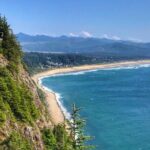
Your flight starts with a round-trip ride from Troutdale and a meet-up at Envi Adventures (1350 NW Perimeter Way, Troutdale). Then the route sets you up for two big “Oregon identity” hits before it goes volcano-mode: Portland and the Columbia River Gorge.
This order matters. Portland gives you reference points—river shape, city scale, and the backdrop of snow-capped Mt. Hood (when visibility allows). Then the Gorge makes everything click, because from the air you can see the canyon’s logic: how the river carved its way through the region and why this area is such a classic Pacific Northwest corridor.
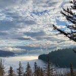
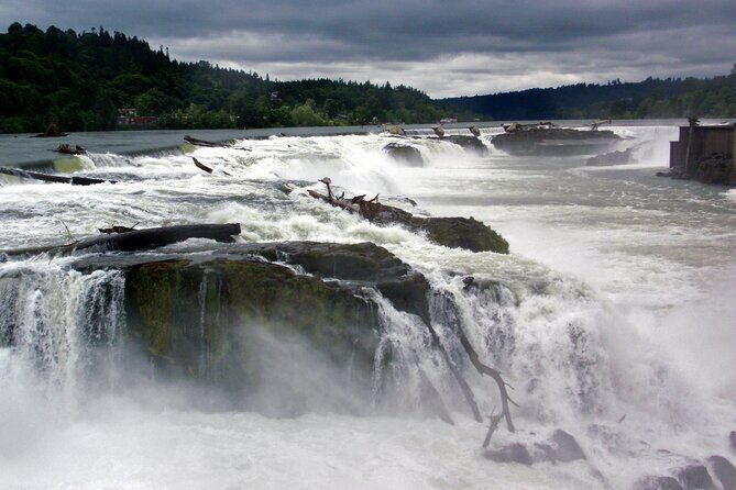
Stop: Columbia River Gorge (the canyon you can actually measure)
One of the smartest parts of this tour is that it doesn’t jump straight to the crater. You’ll first fly into Oregon’s famous Columbia River Gorge, a dramatic canyon carved by the Columbia River.
From the air, the Gorge’s size becomes more than a description. The National Scenic Area stretches about 85 miles and includes portions of three Oregon and three Washington counties, which the pilot can help you “place” as you pass overhead. The benefit for you is clarity: it’s easier to understand the geography that surrounds Mt. St. Helens once you’ve seen the Gorge from above.
Possible downside: if weather is thick or visibility is limited, canyon-detail can get muted. In that case, the pilot’s job shifts to safer routing and broader viewpoints rather than precise tracing of features.
Flying above Portland: rivers, Mt. Hood, and city scale
Next up, you’ll fly above Portland, Oregon’s largest city, sitting between the Columbia and Willamette rivers. You’re also in the shadow of snow-capped Mt. Hood when conditions allow, which adds a neat layered look to the skyline.
This segment works well because it’s visual context. When you later see Mt. St. Helens, you’re not just looking at a volcano—you’re looking at it relative to a real place you’ve likely heard of. Portland’s river system is especially easy to spot from the air, and that helps you keep your bearings quickly.
If you care about photography, this is usually where you’ll want to start paying attention to angle and glare. The tour is on a plane, so your best shots depend on the aircraft position and lighting that day.
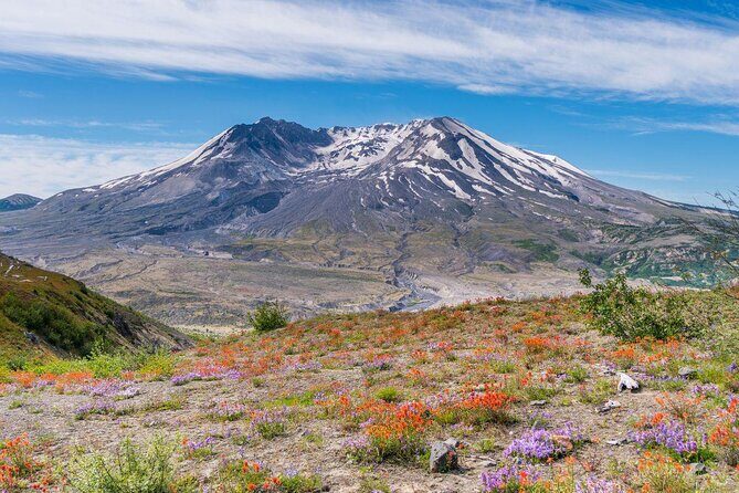
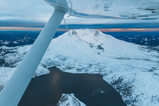
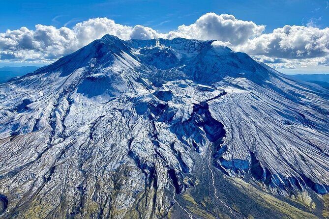
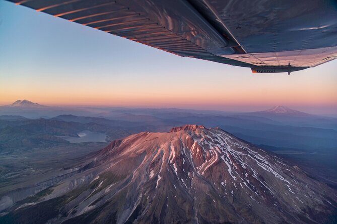
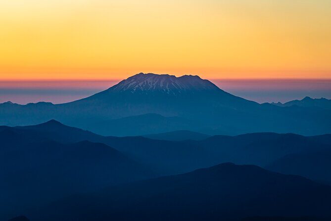
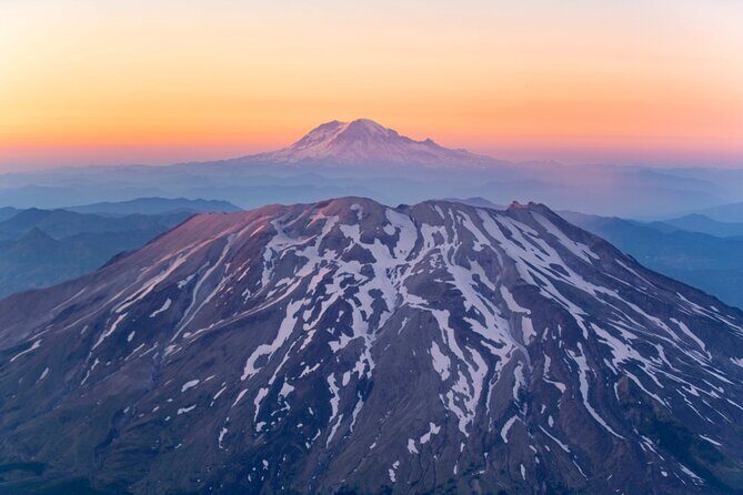
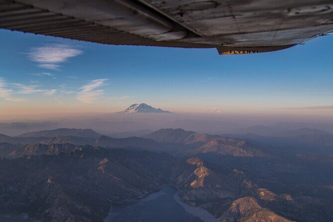
Stop: Mt. St. Helens crater views and the May 18, 1980 story
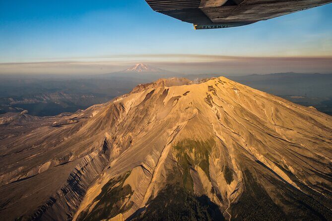
Then you get to the main event: flying above and around the crater of Mt. St. Helens. The volcano is most famous for its major eruption on May 18, 1980, described as the deadliest and most economically destructive volcanic event in U.S. history.
What makes this meaningful is the combination of timing and explanation. The pilot’s narration helps connect what you see on the ground—or at least the shape and texture of it—to the eruption’s scale and impact. Even if you’ve read about 1980, it’s different when you can look down and recognize the “after” from above.
Also, note that this isn’t a helicopter ride. That can affect how close you feel to the crater visually. But for many people, the trade-off is worth it because you still get aerial perspective and guided context in a short, efficient flight.
- The Real Portland Tour: City and 3 Lighthouses Historical Tour with a Real Local
★ 5.0 · 1,448 reviews


Stop: Seeing the eruption’s destruction from the air
After the crater segment, the tour includes flying above and around the destruction left by the eruption. This is the part where your brain starts doing pattern-matching: where land changed, where impacts spread, and how the area looks in patches rather than one uniform scar.
You’ll likely come away with a more grounded sense of what “destruction” means geographically. In the air, it’s often easier to see the edges of damage, the outlines of altered terrain, and the way recovery or different surface types create visual lines. That’s the kind of understanding that a viewpoint pull-off simply can’t replicate in the same way.
One caution: what you can make out depends heavily on weather, cloud cover, and light. If the pilot alters routing due to conditions, you may get less detail in specific areas. But you still should get a powerful overview of the eruption zone when visibility cooperates.
Your pilot matters more than you think
The pilot isn’t just driving the plane. In this kind of regional aerial tour, the difference between an okay flight and a memorable one is interpretation—naming what you’re seeing and helping you understand it in real time.
One review highlights that the pilot, John, was very informative about the sights and explained the landscapes surrounding them. You can expect that kind of commentary here: the “why” behind the view. That also helps if you’re not a geology person. You don’t need a textbook. You need someone translating the view into something you can recognize and remember.
The good news: a maximum of 5 travelers means it’s easier for the pilot to keep the group oriented and adjust explanations based on what people are asking.
Plane vs helicopter: the photo reality check (with fairness)
You might have heard the classic debate: helicopters give better visibility for photos. In this tour, that’s a legitimate consideration because it’s operated with airplanes, not helicopters.
From your perspective, here’s what that can mean:
- You may have fewer angles to work with compared to an open-door helicopter setup.
- Visibility depends on cloud cover, sun position, and where you’re seated.
That said, the flight is still built around seeing key features from above—Portland and the Gorge, then the crater and eruption zone. So even if your photos aren’t as “close” as you hoped, the view itself can still be the main event. And when someone is doing the narration well, you’ll remember what you learned more than how perfect the shot was.
Weather and alternate routing: how to stay flexible
Let’s talk about the biggest operational truth: this tour is very weather dependent and may result in alternate routing at the pilot’s discretion. That means your exact sequence or how you see each area can shift based on conditions.
Plan for flexibility in two ways:
- Have a calm mindset on the day of your flight. If clouds roll in, you’re still in good hands with a pilot deciding what’s safest and what’s visible.
- Choose clothing that works for quick changes. Even if the tour is short, air rides can feel different with wind and altitude.
If you’re traveling with a tight schedule, consider booking the earliest available flight that day so you have options if the day needs rerouting.
Timing, group size, and comfort on a small flight
This is an approximately 1-hour experience, with the tour starting and ending at the meeting point. The group size is capped at 5 travelers, and that small number is part of the reason the experience can feel personal rather than like you’re stuck listening to a lecture while scanning out the window.
A few practical details to respect:
- Arrive at least 30 minutes prior to the start time.
- Bring your mobile ticket (the tour uses mobile ticketing).
- Be ready to share passenger weights when booking, because weight limits are enforced.
Also, there are strict weight rules: 250 lbs per passenger. Group weight caps apply too: up to 600 lbs for a group of 3, and up to 925 lbs for a group of 5 (with individual caps at 250 lbs). If you’re right near the upper limit, it’s smart to confirm your numbers early so you don’t get last-minute surprises.
Who should book this Mt. St. Helens air tour
This tour is a great fit if you want:
- A fast, one-hour aerial overview rather than a long road trip.
- Pilot narration so the views connect to real geography and history.
- A small-group experience from Troutdale with comfortable round-trip transport.
It’s especially good for couples, friends, and solo travelers who are comfortable with the idea that weather may change the exact routing. And since it’s offered in English and most travelers can participate, it’s fairly straightforward.
Families should plan carefully. Children must be accompanied by an adult, and your group needs to stay within weight rules.
If you are someone who needs maximum photo visibility and wants close-up angles for crater shots, you might feel a little restricted knowing it’s an airplane rather than a helicopter. But if you’re okay with “a guided view from the sky,” you’re likely to love it.
Should you book this Mt. St. Helens Air Tour with Envi Adventures?
If your goal is to see Portland and the Columbia River Gorge from the air, then cap it with Mt. St. Helens crater and the eruption aftermath, this is a strong choice. The small group size, pilot-led storytelling, and the tight one-hour format make it feel like a focused experience rather than a rushed checklist.
I’d book it if you can be flexible about weather and you’re excited by aerial perspective. I’d hesitate only if you need guaranteed, detailed crater viewing in specific conditions or you’re photo-focused to the point that airplane visibility won’t meet your expectations.
FAQ
How long is the Mt. St. Helens Air Tour?
It’s about 1 hour (approx.).
What does the tour cost?
The price is $355.00 per person.
Where does the tour start from?
It meets at Envi Adventures, 1350 NW Perimeter Way, Troutdale, OR 97060, USA, and it ends back at the meeting point.
Is this tour operated with a helicopter?
No. This tour is operated with airplanes, not helicopters.
Does weather affect the route?
Yes. The tour is very weather dependent and may result in alternate routing at the pilot’s discretion.
What is the maximum group size?
The maximum is 5 travelers.
What are the weight requirements?
The total weight per passenger must be 250 lbs. Group weight limits also apply: not to exceed 600 lbs per group of 3, or 925 lbs per group of 5, with individual weights not to exceed 250 lbs. Weights must be provided when booking.
You Might Also Enjoy
More Tours in Portland
- The Real Portland Tour: City and 3 Lighthouses Historical Tour with a Real Local
★ 5.0 · 1,448 reviews


More Tour Reviews in Portland
- The Real Portland Tour: City and 3 Lighthouses Historical Tour with a Real Local
★ 5.0 · 1,448 reviews